The Geology of Baume‑les‑Messieurs
A showcase of geological processes
Nestled in the heart of the Jura, the village of Baume-les-Messieurs is far more than just a charming settlement: its landscape is a brilliant showcase of geological processes, tectonic history, karstic evolution and surface erosion.
1. Setting the Stage: The Jura and the Reculée
In order to understand Baume-les-Messieurs, we first need to step back and look at the broader geological context of the Jura mountains and the phenomenon of the “reculée”.
1.1 The Plateau and its Carbonate Foundation
The region lies on the western edge of the Jura mountain chain, at the boundary of the so-called “first plateau” (in local French usage). According to geological summaries, the area is underlain by thick horizontal layers of limestones deposited during the Middle Jurassic (Bajocian-Bathonian) and earlier marly or marno-calcareous layers of the Lias and Trias. (Wikipedia)
These limestones formed when a shallow sea covered much of the region. Over millions of years, sedimentation accumulated carbonate layers, which later hardened into the rocks we now see.
1.2 What is a Reculée?
The term reculée (sometimes translated as “steephead valley” or “blind valley”) is key to the Jura landscape. Geographers define it as:
“a long valley that penetrates into a calcareous plateau of horizontal layers and that ends abruptly in a ‘bout du monde’ (dead-end), at the head of which springs a resurgence.” (Lons-le-Saunier Tourisme)
In simpler terms: the plateau of hard limestones is dissected by valleys that run inward, often deeply, with steep sides, and which terminate at the head in springs or caves. These are very typical of the Jura’s morphology.
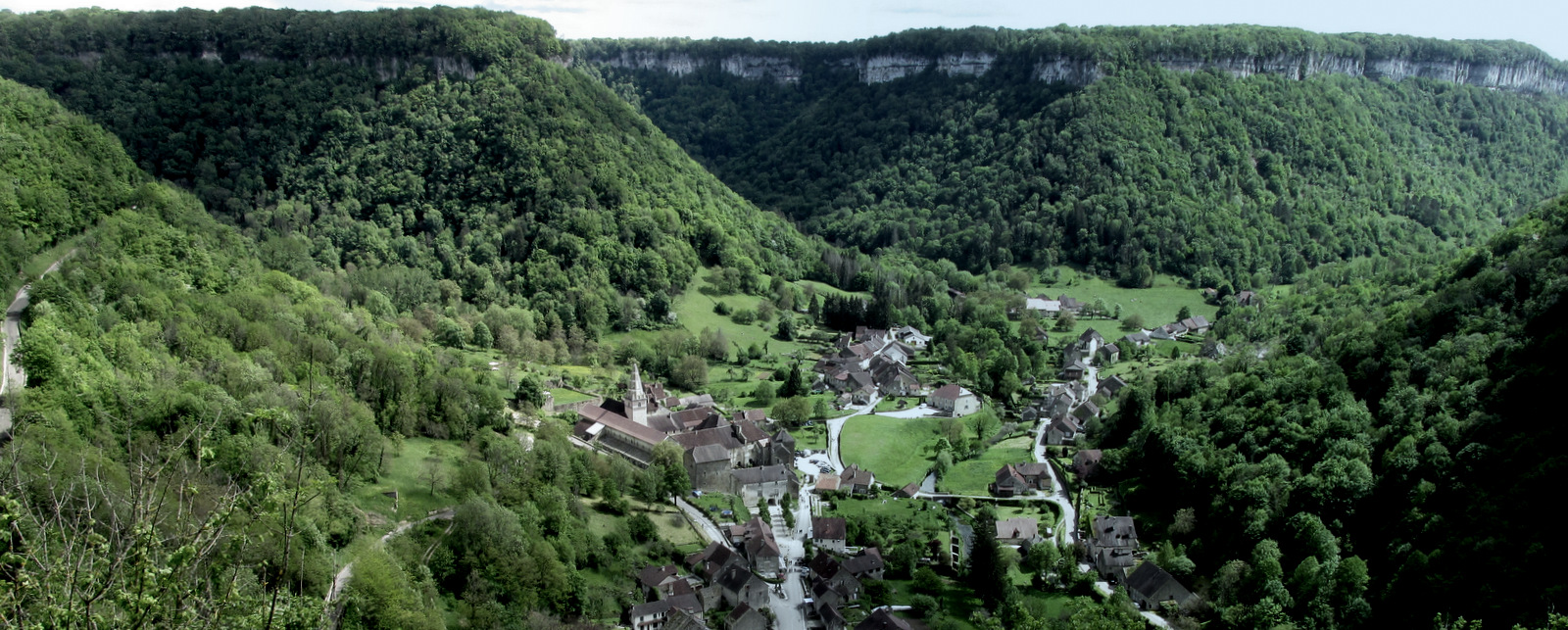
The Reculée of Baume-les-Messieurs is widely regarded as the most emblematic example in the region. (Lons-le-Saunier Tourisme)
1.3 Morphology of the Site
The recess-valley (“reculée”) at Baume penetrates the plateau for several kilometres and branches into two major arms: a northern branch (towards Ladoye-sur-Seille) and a southern branch reaching the village of Baume-les-Messieurs. (Lons-le-Saunier Tourisme)
The flanks of the valley are steep limestone cliffs, rising many tens (often over a hundred) of metres above the valley floor. The bottom is effectively closed off at the head by cliffs and caves/resurgences, giving it that “amphitheatre” feel. (Wikipedia)
2. The Formation Story: From Sea Floor to Deep Valley
How did this dramatic landscape come about? There are several sequential geological and geomorphologic steps.
2.1 Marine Sedimentation and Rock Formation
First, as mentioned, the area was under a shallow sea in the Jurassic era. Over time, carbonate sediments accumulated—shells, coral, marine limestones—forming thick deposits of limestone. Later, layers of marl and marno-calcareous rocks from deeper or transitional conditions were also laid down. (Wikipedia)
Post-deposition, these rocks were uplifted (tectonically) and exposed as part of the Jura chain. They now form a largely horizontal or gently inclined stack, with the harder limestones forming resistant cornices. (Wikipedia)
2.2 Karstification and Underground Drainage
Once exposed, the limestones were made vulnerable to water infiltration: rain, snow-melt, and glacial/periglacial processes exploit cracks and joints in the rock. Over time, this creates a karstic network—underground cavities, conduits, passages through which water flows. At Baume this has been very important. (lithotheque.ac-montpellier.fr)
Such networks often lead to drainage underground rather than only on the surface; at the head of the valley this results in springs or resurgences where the underground water emerges. The river Rivière du Dard is one such resurgence: it emerges from the caves and creates the waterfall at Baume. (Wikipedia)
2.3 Valley Deepening and Retraction: The Reculée Evolution
The formation of the valley (reculée) is not purely one of surface river-erosion cut-down (though that is part of it), but rather of headward retreat (progressive backward erosion) and collapse/growth of the karstic voids. At Baume, the process can be summarized as:
- Water infiltrates at higher elevations, dissolves limestone along joints/faults, enlarging cavities.
- Eventually, collapse or subsidence occurs, giving steep flanks and a closed head (a “cul-de-sac”).
- Continued headward retreat of the valley within the plateau gradually deepens the valley and steepens the sides. The branch arms are digitated (i.e., have multiple small side valleys). (Wikipedia)
Indeed, for the Baume valley, it is noted that the morphology shows a progressive deepening rather than ‘one big collapse’. (Wikipedia)
The presence of faults controls where the valley forms: in the Baume area, several fault systems guided the shape of the valley as it carved into the plateau. (Wikipedia)
2.4 Surface Erosion, Climatic Amplification & Pleistocene Effects
Surface erosion (rain, river action, mass‐wasting, freeze-thaw in periglacial times) further shaped the valley, steepening walls, promoting rockfalls and talus slopes, and removing softer layers (marl) below harder limestones, thereby creating the typical steep step-like profile (hard cap rock over softer material). (Wikipedia)
Glacial and periglacial influences in the Jura encouraged frost action, meltwater, and high runoff, which also accelerated valley formation. The present valley is thus a product of long, gradual processes, combining underground and surface erosion, tectonics and climate.
3. Key Landscape Features at Baume-les-Messieurs
Let’s pull out a few of the standout features that you can visit, each of which tells part of the story.
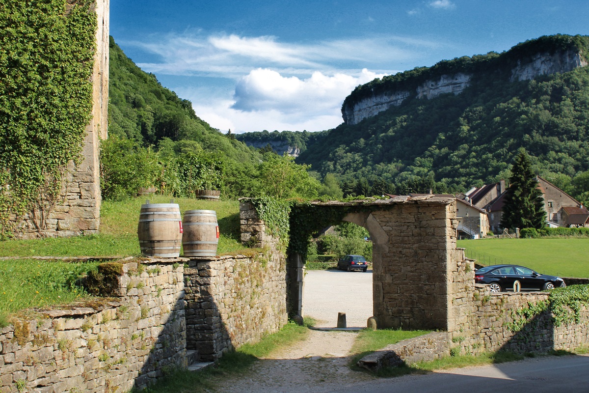
3.1 The Limestones and Cliff Cornices
As you approach Baume-les-Messieurs, you’ll notice the vertical limestone cliffs that flank the valley. These are the harder limestones of the Middle Jurassic, forming cornices at the top of the slope. Beneath them lie slopes composed of softer marnes/marno-calcareous layers (from Lias/Trias) that yield more to erosion. (Wikipedia)
This “hard rock cap / softer slope” structure is typical of the Jura’s plateaux and their dissected edges: the harder layers protect the plateau top, while the softer ones erode more quickly, giving the steep-wall profile.
3.2 The Gorge & Branching Valley
The valley floor is relatively narrow, and the sides rise steeply. The valley is not a simple U-shape or V-shape but has a complex branching (digitated) structure: two main arms and several side extensions. (Lons-le-Saunier Tourisme)
At the head of the valley the passage narrows and often ends in cliffs and caves — the hallmark of a reculée. At Baume the resurgence of the Dard emerges here. This morphological pattern is very instructive: the valley has been incised backward into the plateau.
3.3 The Cave / Karst System
Underneath the plateau, water has carved out an underground network. The caves beneath Baume are impressive: they begin with a huge “cathedral-like” entrance (70 m wide), lead into chambers 20-70 m high, with subterranean lakes and rivers. (Lons-le-Saunier Tourisme)
This underground system is not just a curiosity: it is central to the formation of the valley. The Dard river flows from this cave system as a resurgence. The presence of such karstic drainage means that much of the water does not simply flow on the surface but travels underground, dissolving rock and undermining the plateau.
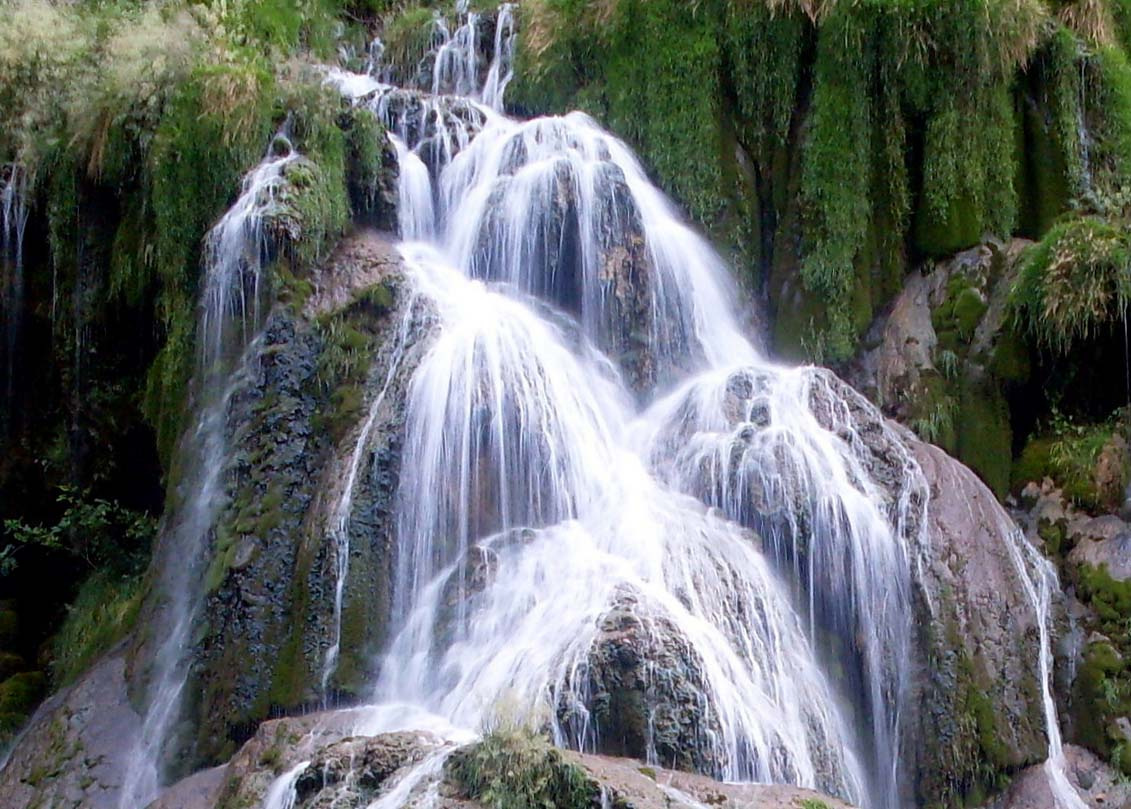
3.4 The Cascade of Travertine (Tuf)
At the very head of the valley, the river Dard emerges from the underground and plunges as a waterfall — the famous Cascade de tufs. The term “tufs” refers to travertine (a form of calcium carbonate deposit) that precipitates from the water, building up natural dams (gours) and forming the spectacular cascade structure. (Wikipedia)
This feature is especially interesting because it directly shows the interplay of geology, hydrology and biology: the water picks up dissolved calcium from the limestone, then as it emerges and degasses CO₂ or slows down, the calcite precipitates, forming travertine. Over time these build up to create the tiered waterfall and pools you see.
3.5 Rockfalls, Talus and Slope Dynamics
The steep limestone cliffs are subject to rock-fall and slumping; the valley is rimmed by talus slopes, collapsed blocks, and colluvium at the base. For instance, near the plateau of Sermu a large ancient rock-fall is visible at the foot of the cliff: a chaotic mass covering about 7 hectares. (Wikipedia)
These processes continue to shape the valley slowly. The steepness means freeze-thaw, water infiltration and mechanical weathering are persistent.
Why Baume-les-Messieurs Is Geologically Special
-
It is widely regarded as the most representative example of the Jura “reculée” morphology. (Wikipedia)
-
The clear stratigraphic succession (Jurassic limestones over Lias/Trías marls) visible on the valley walls gives an accessible cross-section of the Jura’s geological history.
-
The karstic system is active and visible: caves, resurgence, travertine cascades.
-
The landscape has high visual impact: deep valley, vertical cliffs, closed-in bowl feeling — all of which make the geological story legible to the visitor.
-
The site is protected and designated (part of a Natura 2000 zone) recognising its natural and geological value. (inpn.mnhn.fr)
Tips for the Visitor
If you’re going to visit Baume (or photograph it, or explore it in more detail), here are some suggestions:
-
Observe from above: From belvedères on the plateau (for example the “Échelles de Sermu” or “Belvédère des Roches” towards Crançot) you can see the full bowl shape of the valley and appreciate its depth. (reservation.jura-tourism.com)
-
Walk the valley floor: Walk through the village up to the cascade of tufs at the head of the valley. Along the way note the limestone cliffs, the vegetation changes (steep shaded slopes, moist micro-climates), and the change in rock colour/texture.
-
Visit the cave/grottes: If you can tour the caves (with a guide), you’ll see the subterranean side of the valley’s formation. Look for stalactites, the river coursing through, evidence of water tunnels.
-
Cascade & travertine: At the waterfall of the Dard, look closely at the travertine deposits: how they coat vegetation/rocks, how the water shapes the travertine dams and pools. In summer the flow may be light, but after rain the surge is dramatic. (Jura Tourisme)
-
Look for stratigraphy & faults: If you’re geologically literate (or willing to ask your guide), observe the layers of rock: look at how the plateau top is formed of harder limestone, slopes of softer marls. Look for evidence of fault lines (especially near the head of the valley) that helped initial incision. (Wikipedia)
-
Time of day & season: The valley’s orientation and the steep walls mean early morning light or late afternoon often give dramatic shadows.
-
Winter can accentuate the cliffs (ice, frost, lower sun angle) and in rainy periods the waterfall is at its most powerful.
A rich palette of phenomena to explore
Baume-les-Messieurs is a geological gem: the convergence of sedimentary history, tectonic uplift, karst processes, erosion and surface topography all in one accessible place.
For anyone interested in “place and geology”, it offers a rich palette of phenomena to explore—rock types, cave systems, waterfalls built by travertine, striking morphology and interaction with human settlement.